 Pennsylvania Light Pollution Maps
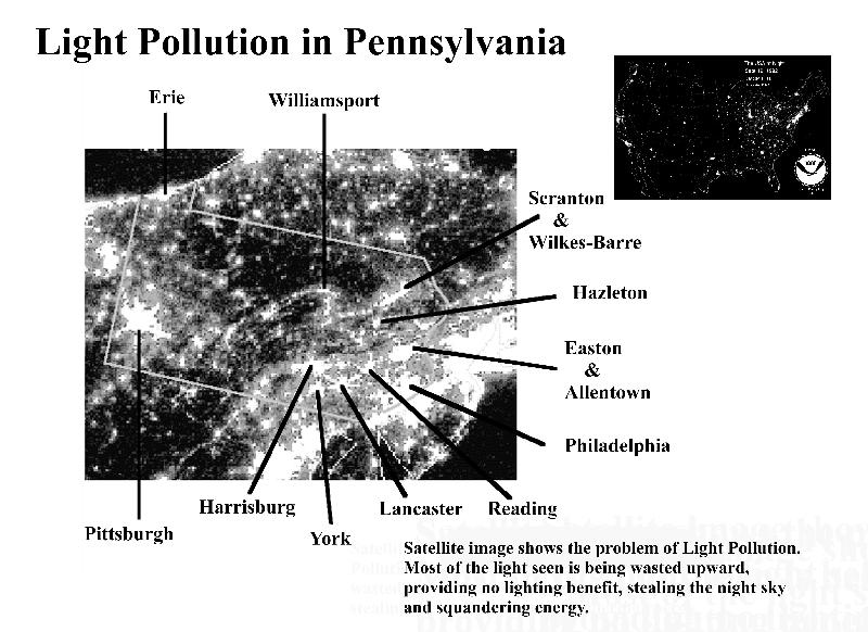
ABOVE: PENNSYLVANIA SATELLITE IMAGE
This satellite photograph of PA taken at night shows light that is traveling upward. Although part of this light is reflected from the ground, much of it is direct uplight wasted by poorly designed outdoor lighting fixtures. Direct uplight serves no useful purpose and is a waste of energy. Light pollution from these fixtures causes disabling glare to motorists and pedestrians, annoying light trespass on neighboring properties and skyglow that interferes with our view of a natural night sky. Excessive artificial lighting at night also interferes with the feeding and breeding patterns of nocturnal animals.
Artificial Night Sky Brightness
in Pennsylvania:
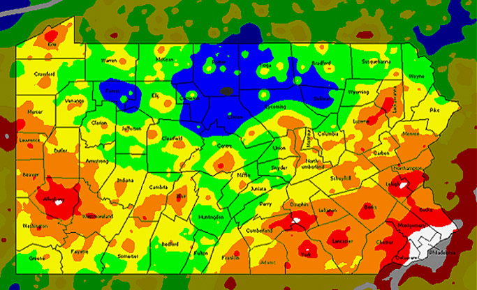
The light pollution map of Pennsylvania below is based on nighttime images obtained from the Defense Meteorological Satellite Program and is taken from the map of North America from the World Atlas of Artificial Sky Brightness.
 Click here for original North America map by the Light
Pollution Science and Technology Institute
Click here for original North America map by the Light
Pollution Science and Technology Institute
Colors correspond to ratios between the artificial sky brightness and the natural sky brightness of: <0.11 (black), 0.11-0.33 (blue), 0.33-1 (green), 1-3 (yellow), 3-9 (orange), >9 (red). For details Click Here.
Credit/copyright statement:
Credit: P. Cinzano, F. Falchi (University of Padova), C. D. Elvidge (NOAA National Geophysical Data Center, Boulder). Copyright Royal Astronomical Society. Reproduced from the Monthly Notices of the RAS by permission of Blackwell Science.
The map below is a crop of the North America image showing county boundary lines for Pennsylvania:
For a detailed explanation of the color code used by Attilla Danko on his Clear Sky Chart home page; see the Cherry Springs State Park Light Pollution Map.
Sky Quality Meter Log Hopewell Big Woods